


Mappa Pittorica Antica del Nord-Pas-de-Calais di Liozu, 1951: Lille, Dunkerque, Valenciennes, Douai, Cambrai
Compra 2, Ricevi 1 Gratuito
Se aggiungi 2 articoli al tuo carrello, puoi aggiungere un terzo prodotto gratuitamente.
Questo vale per tutte le mappe e opere d'arte, comprese le opere personalizzate e su misura. Puoi ordinare 3 dello stesso articolo, o 3 articoli diversi.
Questo equivale a uno sconto del 33%, che sarà il maggiore sconto disponibile nel mio negozio quest'anno.
Ti prego di approfittare dell'offerta e di coprire le tue pareti con bellissime mappe e opere d'arte!
Contattami se hai domande.
-
![]() Handmade in Australia
Handmade in Australia

-
FREE worldwide delivery in 2-3 days ⓘ
Free delivery in 2-3 days
Your map should be delivered in 2-3 working days with free delivery, worldwide.
We make maps by hand locally in 23 countries, including Australia
![]() . If you're buying a gift for someone in another country, we will make the map locally to them.
. If you're buying a gift for someone in another country, we will make the map locally to them.You will never pay import tax or customs duty.
Express delivery is available at checkout which can reduce the delivery time to 1-2 days.
Please note that personalised maps, and larger framed maps, can take longer to produce and deliver.
If you need your order to arrive by a certain date, contact me and we can discuss your options.
-
Complimentary gifting & design advice
ⓘ
Complimentary gifting & design advice
Available almost 24/7 on WhatsApp and email — we usually reply within minutes. We can help you:
- Choose a perfectly personalised gift
- Send a digital gift preview to the recipient
- Pick the ideal size for your wall
- Select the right finish and frame
Quick, friendly advice so you can order with confidence.
For last minute gifts, consider buying a digital gift card. We have over 5,000 maps and art prints to choose from.
-
90-day money back guarantee
ⓘ
90 giorni per restituire e ricevere un rimborso
I prodotti possono essere restituiti entro 90 giorni per un rimborso completo, o cambio con un altro prodotto.
Per articoli personalizzati e su misura, potremmo offrirti un credito in negozio o una carta regalo non scadente, poiché non possiamo rivendere ordini personalizzati.
Se hai domande, contattaci. Per ulteriori informazioni, consulta la nostra politica di restituzione e cambio.

This is a museum-grade archival print from the original 1951 map — restored in our workshop and made to order on 220gsm archival matte paper or 400gsm artist's cotton canvas with pigment inks.
Professional framing & free personalisation available
1. Select your size
Click here to order a custom size.
2. Frame & personalise your map
Make your map unique with framing, hand-drawn customisation, vintage ageing, pop art text, unique 3D styling and more.


Gift message & custom finish

If you want to add a gift message, or a finish (jigsaw, aluminium board, etc.) that is not available here, please request it in the "order note" when you check out.
Every order is custom made, so if you need the size adjusted slightly, or printed on an unusual material, just let us know. We've done thousands of custom orders over the years, so there's (almost) nothing we can't manage.
You can also contact us before you order, if you prefer!

- Handmade locally. No import duty or tax
- FREE worldwide delivery
- Love it or your money back (90 days)
- Questions? WhatsApp me any time
Own a piece of history
5,000+ 5 star reviews


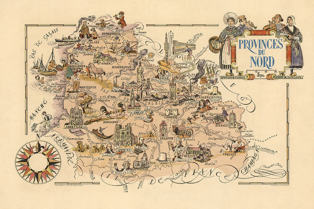
La mappa delle "Provinces du Nord", realizzata dal rinomato Jacques Liozu nel 1951, è un'abile fusione di arte e cartografia, catturando l'essenza del Dipartimento del Nord in Francia. Questa mappa è un vivido arazzo del ricco patrimonio culturale e storico della regione, meticolosamente illustrata con una rosa dei venti decorativa e un rilievo pittorico. L'opera di Liozu è rinomata per i suoi dettagli intricati e gli elementi tematici, rendendo questa mappa non solo uno strumento di navigazione ma una narrazione visiva dell'identità della regione del Nord.
Jacques Liozu, un distinto cartografo, è celebrato per la sua capacità di infondere le sue mappe sia di bellezza estetica che di profondità storica. Il suo lavoro sulla mappa delle "Provinces du Nord" non fa eccezione, mostrando il suo talento nel creare mappe che sono tanto informative quanto visivamente affascinanti. Le mappe di Liozu presentano spesso illustrazioni dettagliate di monumenti, abiti tradizionali ed eventi storici, fornendo una visione completa delle regioni che ha rappresentato. Questa mappa è una testimonianza della sua dedizione a preservare e celebrare il patrimonio regionale attraverso la cartografia.
Il design della mappa delle "Provinces du Nord" è una fusione armoniosa di elementi artistici e tematici. La rosa dei venti decorativa, orientata con il nord verso il margine superiore sinistro, aggiunge un tocco di eleganza, mentre il rilievo pittorico dà vita al paesaggio. La mappa è adornata con illustrazioni di mestieri tradizionali, attività marittime e scene agricole, riflettendo i diversi aspetti culturali ed economici della regione del Nord. Le rappresentazioni artistiche di monumenti storici, come cattedrali e castelli, migliorano ulteriormente l'appeal visivo e il significato storico della mappa.
Questa mappa offre uno sguardo affascinante sulle città e i paesi della regione del Nord, tra cui Lille, Dunkerque, Valenciennes e Douai. Ogni insediamento è rappresentato con meticolosa attenzione ai dettagli, evidenziando i loro stili architettonici unici e l'importanza storica. La mappa presenta anche punti di riferimento notevoli e caratteristiche naturali, come fiumi, corsi d'acqua e il patrimonio costiero della regione. L'inclusione di festival locali, tradizioni culinarie e folklore aggiunge profondità alla mappa, offrendo una visione completa del paesaggio culturale della regione.
Storicamente, la mappa delle "Provinces du Nord" è significativa poiché cattura l'essenza della regione del Nord a metà del XX secolo, un periodo di ricchezza culturale e riflessione storica. La mappa funge da documento visivo del patrimonio della regione, mostrando la sua connessione con le aree vicine e il suo ruolo negli eventi storici. Gli elementi artistici, come il cartiglio del titolo ornato e i disegni decorativi del bordo, riflettono il contesto storico della mappa e gli stili cartografici dell'epoca. Questa mappa non è solo un prezioso artefatto storico ma anche un bellissimo pezzo d'arte che celebra l'eredità della regione del Nord.
Città e paesi in questa mappa
- Lille
- Dunkerque
- Valenciennes
- Douai
- Cambrai
- Hazebrouck
- Maubeuge
- Avesnes
- Bergues
- Bailleul
- Cassel
- Gravelines
- Saint-Amand
- Le Quesnoy
- Orchies
- Tourcoing
- Roubaix
- Armentières
- Saint-Omer
- Béthune
Caratteristiche e punti di riferimento notevoli
- Rosa dei venti decorativa orientata con il nord verso il margine superiore sinistro.
- Illustrazioni di abiti tradizionali indossati dalle persone nella regione del Nord.
- Rappresentazioni pittoriche di monumenti storici come cattedrali e castelli.
- Illustrazioni di attività marittime, che riflettono il patrimonio costiero della regione.
- Rappresentazioni di attività agricole, che evidenziano gli aspetti rurali della regione.
- Rappresentazione artistica della Battaglia di Dunkerque.
- Illustrazioni di mestieri e arti tradizionali.
- Rilievo pittorico che mostra le caratteristiche del paesaggio della regione.
- Elementi decorativi di bordo con design floreali e a ricciolo.
- Rappresentazione del patrimonio industriale della regione, comprese fabbriche e miniere.
- Illustrazioni della fauna e della flora locali.
- Rappresentazione artistica di eventi storici e figure significative per la regione del Nord.
- Rappresentazione visiva della rete di trasporti della regione, comprese strade e ferrovie.
- Illustrazioni di festival locali ed eventi culturali.
- Rappresentazione artistica del patrimonio culinario della regione, comprese le pietanze tradizionali.
- Rappresentazioni del folklore e delle leggende locali.
- Illustrazioni degli stili architettonici regionali.
- Rappresentazione dei fiumi e delle vie d'acqua della regione.
- Elementi artistici che riflettono il legame della regione con le aree vicine.
- Cartiglio decorativo con lettering ornato e illustrazioni.
Contesto storico e di design
- Mappa pittorica a colori del Dipartimento del Nord, Francia.
- Parte dell'attuale regione Nord-Pas-de-Calais.
- Il rilievo è mostrato in modo pittorico.
- Data di creazione: 1951
- Cartografo/Editore: Jacques Liozu
- Jacques Liozu era noto per la creazione di mappe dettagliate e artistiche che spesso includevano elementi pittorici e dettagli tematici.
- La mappa è tematica e pittorica, focalizzandosi sugli aspetti culturali e storici della regione del Nord.
- Mette in evidenza vari punti di riferimento, eventi storici e icone culturali.
- La mappa è progettata in uno stile pittorico e tematico, ricca di illustrazioni ed elementi decorativi.
- Presenta rappresentazioni artistiche di punti di riferimento, persone in abiti tradizionali e scene storiche.
- La mappa fornisce una rappresentazione visiva della ricchezza culturale e storica della regione del Nord nella metà del XX secolo.
- Serve come documento storico che riflette gli stili artistici e cartografici dell'epoca.
Si prega di controllare attentamente le immagini per assicurarsi che una specifica città o luogo sia mostrato su questa mappa. Puoi anche contattarci e chiedere di controllare la mappa per te.
Questa mappa sembra fantastica in ogni dimensione, ma consiglio sempre di optare per una dimensione più grande se hai spazio. In questo modo puoi facilmente distinguere tutti i dettagli.
Questa mappa appare incredibile in dimensioni fino a 70in (180cm). Se stai cercando una mappa più grande, per favore contattaci.
Il modello nelle immagini dell'elenco tiene in mano la versione 24x36in (60x90cm) di questa mappa.
La quinta immagine dell'elenco mostra un esempio del mio servizio di personalizzazione della mappa.
Se stai cercando qualcosa di leggermente diverso, dai un'occhiata alla mia collezione delle migliori mappe antiche per vedere se qualcosa attira la tua attenzione.
Per favore contattami per controllare se una certa posizione, punto di riferimento o caratteristica è mostrato su questa mappa.
Questo sarebbe un meraviglioso regalo per un compleanno, Natale, Festa del Papà, un addio al lavoro, un anniversario o un regalo per una nuova casa per qualcuno delle aree coperte da questa mappa.
Questa mappa è disponibile come stampa giclée su carta opaca archiviabile priva di acidi, oppure puoi acquistarla incorniciata. La cornice è una semplice cornice nera che si adatta alla maggior parte degli stili. Ti preghiamo di contattarci se desideri un colore o un materiale diverso per la cornice. Le mie cornici sono dotate di un vetro acrilico super chiaro di grado museale (perspex/acrylite), che è significativamente meno riflettente del vetro, più sicuro e arriverà sempre in perfette condizioni.
This map is also available as a float framed canvas, sometimes known as a shadow gap framed canvas or canvas floater. The map is printed on artist's cotton canvas and then stretched over a handmade box frame. We then "float" the canvas inside a wooden frame, which is available in a range of colours (black, dark brown, oak, antique gold and white). This is a wonderful way to present a map without glazing in front. See some examples of float framed canvas maps and explore the differences between my different finishes.
For something truly unique, this map is also available in "Unique 3D", our trademarked process that dramatically transforms the map so that it has a wonderful sense of depth. We combine the original map with detailed topography and elevation data, so that mountains and the terrain really "pop". For more info and examples of 3D maps, check my Unique 3D page.
For most orders, delivery time is about 3 working days. Personalised and customised products take longer, as I have to do the personalisation and send it to you for approval, which usually takes 1 or 2 days.
Please note that very large framed orders usually take longer to make and deliver.
If you need your order to arrive by a certain date, please contact me before you order so that we can find the best way of making sure you get your order in time.
I print and frame maps and artwork in 23 countries around the world. This means your order will be made locally, which cuts down on delivery time and ensures that it won't be damaged during delivery. You'll never pay customs or import duty, and we'll put less CO2 into the air.
All of my maps and art prints are well packaged and sent in a rugged tube if unframed, or surrounded by foam if framed.
I try to send out all orders within 1 or 2 days of receiving your order, though some products (like face masks, mugs and tote bags) can take longer to make.
If you select Express Delivery at checkout your order we will prioritise your order and send it out by 1-day courier (Fedex, DHL, UPS, Parcelforce).
Next Day delivery is also available in some countries (US, UK, Singapore, UAE) but please try to order early in the day so that we can get it sent out on time.
My standard frame is a gallery style black ash hardwood frame. It is simple and quite modern looking. My standard frame is around 20mm (0.8in) wide.
I use super-clear acrylic (perspex/acrylite) for the frame glass. It's lighter and safer than glass - and it looks better, as the reflectivity is lower.
Six standard frame colours are available for free (black, dark brown, dark grey, oak, white and antique gold). Custom framing and mounting/matting is available if you're looking for something else.
Most maps, art and illustrations are also available as a framed canvas. We use matte (not shiny) cotton canvas, stretch it over a sustainably sourced box wood frame, and then 'float' the piece within a wood frame. The end result is quite beautiful, and there's no glazing to get in the way.
All frames are provided "ready to hang", with either a string or brackets on the back. Very large frames will have heavy duty hanging plates and/or a mounting baton. If you have any questions, please get in touch.
See some examples of my framed maps and framed canvas maps.
Alternatively, I can also supply old maps and artwork on canvas, foam board, cotton rag and other materials.
If you want to frame your map or artwork yourself, please read my size guide first.
Alcune delle mie vecchie mappe sono ora disponibili come tele incorniciate. Per favore contattami se desideri ordinare una dimensione che non è disponibile nel mio negozio.
Le vecchie mappe su tela sono un'alternativa interessante alle mappe incorniciate in modo convenzionale. A seconda del tuo gusto personale e dell'arredamento della stanza, le mappe su tela possono "risaltare" un po' di più rispetto a una mappa incorniciata.
My maps are extremely high quality reproductions of original maps.
I source original, rare maps from libraries, auction houses and private collections around the world, restore them at my London workshop, and then use specialist giclée inks and printers to create beautiful maps that look even better than the original.
My maps are printed on acid-free archival matte (not glossy) paper that feels very high quality and almost like card. In technical terms the paper weight/thickness is 10mil/200gsm. It's perfect for framing.
I print with Epson ultrachrome giclée UV fade resistant pigment inks - some of the best inks you can find.
I can also make maps on canvas, cotton rag and other exotic materials.
Learn more about The Unique Maps Co.
Map personalisation
If you're looking for the perfect anniversary or housewarming gift, I can personalise your map to make it truly unique. For example, I can add a short message, or highlight an important location, or add your family's coat of arms.
The options are almost infinite. Please see my map personalisation page for some wonderful examples of what's possible.
To order a personalised map, select "personalise your map" before adding it to your basket.
Get in touch if you're looking for more complex customisations and personalisations.
Map ageing
I have been asked hundreds of times over the years by customers if they could buy a map that looks even older.
Well, now you can, by selecting Aged before you add a map to your basket.
All the product photos you see on this page show the map in its Original form. This is what the map looks like today.
If you select Aged, I will age your map by hand, using a special and unique process developed through years of studying old maps, talking to researchers to understand the chemistry of aging paper, and of course... lots of practice!
If you're unsure, stick to the Original colour of the map. If you want something a bit darker and older looking, go for Aged.
Se non sei soddisfatto del tuo ordine per qualsiasi motivo, contattami per un rimborso senza problemi. Si prega di consultare la nostra politica di reso e rimborso per ulteriori informazioni.
Sono molto sicuro che ti piacerà la tua mappa restaurata o la stampa d'arte. Lo faccio dal 1984. Sono un venditore Etsy a 5 stelle. Ho venduto decine di migliaia di mappe e stampe d'arte e ho oltre 5.000 recensioni reali a 5 stelle.
Utilizzo un processo unico per restaurare mappe e opere d'arte che richiede molto tempo e lavoro. Trovare le mappe e le illustrazioni originali può richiedere mesi. Utilizzo tecnologia all'avanguardia e incredibilmente costosa per scannerizzare e restaurarle. Di conseguenza, garantisco che le mie mappe e stampe d'arte siano superiori alle altre - ecco perché posso offrire un rimborso senza problemi.
Quasi tutte le mie mappe e stampe d'arte sembrano fantastiche a grandi dimensioni (200 cm, 6,5 piedi+) e posso anche incorniciarle e consegnarle a te, tramite un corriere speciale per oggetti di grandi dimensioni. Contattami per discutere delle tue esigenze specifiche.
Or try searching for something!


