


Mappa Pittorica Antica dell'Economia del Pacifico di Covarrubias, 1940: Commercio, Risorse, Arte Pre-Seconda Guerra Mondiale

-
![]() Handmade in Australia
Handmade in Australia
-
FREE Christmas delivery (check deadlines)
Free Christmas delivery in 3-4 days
Your map should be delivered in 3-4 working days with free delivery, worldwide.
The deadline for free Christmas delivery has almost passed. Please order as soon as possible and consider using Express Delivery.
We make maps by hand locally in 23 countries, including Australia
![]() . If you're buying a gift for someone in another country, we will make the map locally to them.
. If you're buying a gift for someone in another country, we will make the map locally to them.You will never pay import tax or customs duty.
Check the Christmas delivery guide for order deadlines. Delivery times are starting to slow down, and will continue to slow down towards Christmas.
Express delivery is available at checkout which can reduce the delivery time to 1-2 days.
Please note that personalised maps, and larger framed maps, can take longer to produce and deliver.
If you need your order to arrive by a certain date, contact me and we can discuss your options.
-
90 day money back guarantee
ⓘ
90 giorni per restituire e ricevere un rimborso
I prodotti possono essere restituiti entro 90 giorni per un rimborso completo, o cambio con un altro prodotto.
Per articoli personalizzati e su misura, potremmo offrirti un credito in negozio o una carta regalo non scadente, poiché non possiamo rivendere ordini personalizzati.
Se hai domande, contattaci. Per ulteriori informazioni, consulta la nostra politica di restituzione e cambio.

My maps are rare, museum-grade, restored old maps sourced from libraries, auction houses and private collections across the globe.
Framing & free personalisation available
1. Select your size
2. Frame & personalise your map
There is limited framing & personalisation capacity available. Order by 10am tomorrow for Christmas delivery.


Gift message & custom finish

If you want to add a gift message, or a finish (jigsaw, aluminium board, etc.) that is not available here, please request it in the "order note" when you check out.
Every order is custom made, so if you need the size adjusted slightly, or printed on an unusual material, just let us know. We've done thousands of custom orders over the years, so there's (almost) nothing we can't manage.
You can also contact us before you order, if you prefer!

- Handmade locally. No import duty or tax
- FREE Delivery by Christmas
- Love it or your money back (90 days)
- Questions? WhatsApp me any time
Own a piece of history
5,000+ 5 star reviews


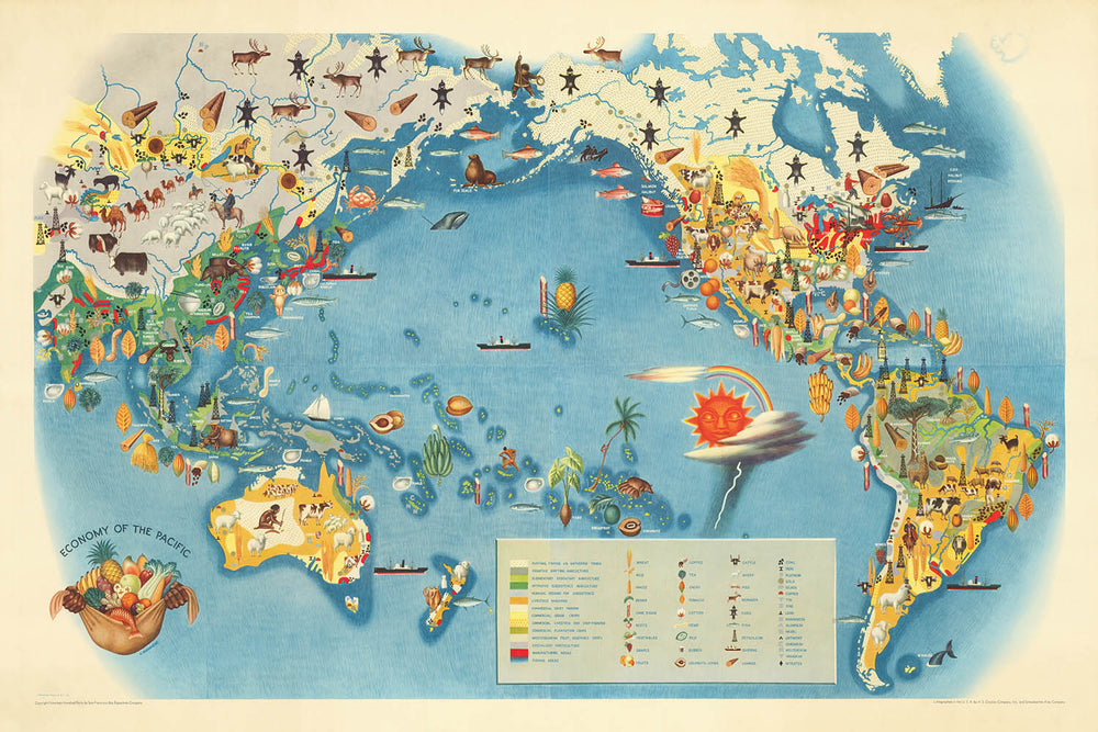
Entra nel vibrante mondo del commercio del Pacifico pre-bellico con "Economia del Pacifico," il capolavoro originale del 1940 di Miguel Covarrubias. Questa straordinaria mappa pittorica, concepita per la celebre serie Pageant of the Pacific, fu commissionata per l'Esposizione Internazionale del Golden Gate del 1939 a San Francisco. Covarrubias, spesso acclamato come "l'Uomo del Rinascimento del Messico," unisce i suoi talenti di pittore, illustratore e antropologo per creare una mappa che è tanto intellettualmente ricca quanto visivamente affascinante. Solo il titolo della mappa evoca una visione ampia del commercio globale, dell'industria e della capacità di adattamento, racchiudendo il dinamismo della Rim del Pacifico alla vigilia di un cambiamento storico monumentale.
"Economia del Pacifico" di Covarrubias è più di un documento geografico: è un arazzo tematico che intreccia il sangue economico di un'intera regione. La mappa illustra vividamente le principali industrie e risorse che definivano il mondo del Pacifico all'inizio del ventesimo secolo, dai campi d'oro dell'Alaska ai campi di riso del Sud-est asiatico, e le vivaci attività ittiche del Giappone. Attraverso una vivace gamma di simboli pittorici e annotazioni disegnate a mano, gli spettatori sono invitati a esplorare le interconnessioni economiche che attraversavano continenti e oceani, plasmando i destini di nazioni e popoli.
Il design della mappa è una lezione magistrale di cartografia stilizzata. Covarrubias adotta un approccio pittorico, evitando i confini politici rigidi a favore di illustrazioni riccamente dettagliate che evidenziano le attività economiche e le risorse naturali. Navi cariche di merci solcano la vasta distesa del Pacifico, mentre vignette di minatori, agricoltori e pescatori animano le coste e le isole. Bordature decorative e illustrazioni agli angoli aggiungono ulteriore profondità, trasformando la mappa in un'opera d'arte che delizia l'occhio mentre informa la mente. La proiezione e la composizione della mappa enfatizzano l'Oceano Pacifico come palcoscenico centrale, unendo le Americhe, l'Asia, l'Australasia e le innumerevoli culture insulari nel mezzo.
Storicamente, questa mappa rappresenta un'istantanea di un mondo sull'orlo della trasformazione. Creata poco prima dell'inizio della Seconda Guerra Mondiale, "Economia del Pacifico" riflette sia l'ottimismo che la complessità del periodo tra le due guerre. Cattura la fascinazione dell'epoca per il progresso, l'estrazione delle risorse e la connettività globale, mentre riconosce sottilmente la diversità dei popoli e delle culture che hanno contribuito al mosaico economico del Pacifico. L'intuizione antropologica di Covarrubias infonde alla mappa un senso di umanità, rendendola un prezioso artefatto per storici, collezionisti e chiunque abbia un'apprezzamento per l'interazione tra arte e storia.
Possedere "Economia del Pacifico" significa possedere una rara finestra sul fermento artistico e intellettuale della fine degli anni '30 e dell'inizio degli anni '40. Che sia esposta in uno studio, in una biblioteca o in una galleria, questa mappa offre un'affascinante varietà di spunti, invitando gli spettatori a tracciare le rotte degli antichi commercianti, immaginare le vite di lavoratori e avventurieri, e apprezzare l'eredità duratura della visione di Covarrubias. È una testimonianza del potere delle mappe non solo di tracciare la geografia, ma di raccontare le storie delle civiltà ai crocevia del cambiamento.
Paesi e regioni su questa mappa
- Nord America (inclusi Canada, Stati Uniti, Messico)
- America Centrale
- America Meridionale (in particolare la costa del Pacifico)
- Est Asia (inclusi Cina, Giappone, Corea)
- Sud-est asiatico (inclusi Filippine, Indonesia, Malesia, Indocina)
- Australia
- Nuova Zelanda
- Isole del Pacifico (inclusi Hawaii, Fiji, Papua Nuova Guinea, Isole Salomone e altre)
- Siberia (Estremo Oriente russo)
- Alaska
Caratteristiche e monumenti notevoli
- Rappresentazioni illustrate delle attività economiche come la pesca, la caccia alle balene, l'estrazione mineraria, l'agricoltura, la silvicoltura e il commercio
- Simboli pittorici per risorse come petrolio, minerali, legname, riso, zucchero e pesce
- Rappresentazioni di navi, barche e rotte marittime che si incrociano nell'Oceano Pacifico
- Illustrazioni stilizzate di lavoratori, agricoltori e popoli indigeni impegnati in attività economiche
- Grandi corpi idrici etichettati: Oceano Pacifico, Mare di Bering, Mare di Corallo, Mare di Tasmania, Mare del Giappone, Mare Cinese Meridionale, Mare delle Filippine e altri
- Principali catene montuose illustrate, come le Ande e le Montagne Rocciose
- Bordi decorativi e vignette angolari che mostrano scene economiche o prodotti
- Rotte di navigazione e percorsi commerciali indicati
- Annotazioni e etichette che evidenziano prodotti o industrie chiave in varie regioni (ad esempio, "grano", "cotone", "oro", "gomma", "perle")
- Rappresentazioni artistiche di isole, arcipelaghi e caratteristiche costiere
Contesto storico e di design
- Creato da Miguel Covarrubias, un rinomato pittore messicano, illustratore, regista e antropologo, spesso definito "l'Uomo del Rinascimento del Messico"
- Realizzato originariamente nel 1940 per l'Esposizione Internazionale di Golden Gate del 1939 a San Francisco
- Parte della serie "Pageant of the Pacific", che includeva sei mappe di dimensioni murali
- Mappa tematica e pittorica del mondo focalizzata sulle attività economiche e risorse della regione del Pacifico
- Altamente stilizzata, pittorica e colorata, utilizzando illustrazioni e simboli per rappresentare attività economiche, risorse e industrie
- Riflette la comprensione contemporanea delle economie del Pacifico prima della Seconda Guerra Mondiale e mette in mostra la prospettiva unica artistica e antropologica di Covarrubias
- Destinata a esposizione e coinvolgimento pubblico, mescolando arte e informazione in modo visivamente coinvolgente
Si prega di controllare attentamente le immagini per assicurarsi che una specifica città o luogo sia mostrato su questa mappa. Puoi anche contattarci e chiedere di controllare la mappa per te.
Questa mappa appare fantastica in ogni dimensione, ma consiglio sempre di optare per una dimensione più grande se hai spazio. In questo modo puoi facilmente distinguere tutti i dettagli.
Questa mappa appare straordinaria in dimensioni fino a 100in (250cm). Se stai cercando una mappa più grande, per favore contattaci.
Si prega di notare: le etichette su questa mappa sono difficili da leggere se ordini una mappa che è 20in (50cm) o più piccola. La mappa è comunque molto attraente, ma se desideri leggere facilmente la mappa, ti preghiamo di acquistare una dimensione più grande.
Il modello nelle immagini dell'elenco tiene in mano la versione 24x36in (60x90cm) di questa mappa.
La quinta immagine dell'elenco mostra un esempio del mio servizio di personalizzazione della mappa.
Se stai cercando qualcosa di leggermente diverso, dai un'occhiata alla mia collezione dei migliori mappe antiche per vedere se qualcosa attira la tua attenzione.
Si prega di contattarmi per verificare se una certa posizione, monumento o caratteristica è mostrata su questa mappa.
Questo sarebbe un meraviglioso regalo di compleanno, Natale, Festa del Papà, partenza dal lavoro, anniversario o inaugurazione della casa per qualcuno delle aree coperte da questa mappa.
Questa mappa è disponibile come stampa giclée su carta opaca archiviata senza acidi, oppure puoi acquistarla incorniciata. La cornice è una semplice cornice nera che si adatta alla maggior parte degli stili. Ti preghiamo di contattarci se desideri un colore o un materiale diverso per la cornice. Le mie cornici sono rivestite con acrilico super chiaro di qualità museale (perspex/acrylite), che è significativamente meno riflettente del vetro, più sicuro e arriverà sempre in perfette condizioni.
This map is also available as a float framed canvas, sometimes known as a shadow gap framed canvas or canvas floater. The map is printed on artist's cotton canvas and then stretched over a handmade box frame. We then "float" the canvas inside a wooden frame, which is available in a range of colours (black, dark brown, oak, antique gold and white). This is a wonderful way to present a map without glazing in front. See some examples of float framed canvas maps and explore the differences between my different finishes.
For something truly unique, this map is also available in "Unique 3D", our trademarked process that dramatically transforms the map so that it has a wonderful sense of depth. We combine the original map with detailed topography and elevation data, so that mountains and the terrain really "pop". For more info and examples of 3D maps, check my Unique 3D page.
For most orders, delivery time is about 3 working days. Personalised and customised products take longer, as I have to do the personalisation and send it to you for approval, which usually takes 1 or 2 days.
Please note that very large framed orders usually take longer to make and deliver.
If you need your order to arrive by a certain date, please contact me before you order so that we can find the best way of making sure you get your order in time.
I print and frame maps and artwork in 23 countries around the world. This means your order will be made locally, which cuts down on delivery time and ensures that it won't be damaged during delivery. You'll never pay customs or import duty, and we'll put less CO2 into the air.
All of my maps and art prints are well packaged and sent in a rugged tube if unframed, or surrounded by foam if framed.
I try to send out all orders within 1 or 2 days of receiving your order, though some products (like face masks, mugs and tote bags) can take longer to make.
If you select Express Delivery at checkout your order we will prioritise your order and send it out by 1-day courier (Fedex, DHL, UPS, Parcelforce).
Next Day delivery is also available in some countries (US, UK, Singapore, UAE) but please try to order early in the day so that we can get it sent out on time.
My standard frame is a gallery style black ash hardwood frame. It is simple and quite modern looking. My standard frame is around 20mm (0.8in) wide.
I use super-clear acrylic (perspex/acrylite) for the frame glass. It's lighter and safer than glass - and it looks better, as the reflectivity is lower.
Six standard frame colours are available for free (black, dark brown, dark grey, oak, white and antique gold). Custom framing and mounting/matting is available if you're looking for something else.
Most maps, art and illustrations are also available as a framed canvas. We use matte (not shiny) cotton canvas, stretch it over a sustainably sourced box wood frame, and then 'float' the piece within a wood frame. The end result is quite beautiful, and there's no glazing to get in the way.
All frames are provided "ready to hang", with either a string or brackets on the back. Very large frames will have heavy duty hanging plates and/or a mounting baton. If you have any questions, please get in touch.
See some examples of my framed maps and framed canvas maps.
Alternatively, I can also supply old maps and artwork on canvas, foam board, cotton rag and other materials.
If you want to frame your map or artwork yourself, please read my size guide first.
Alcune delle mie vecchie mappe sono ora disponibili come tele incorniciate. Per favore contattami se desideri ordinare una dimensione che non è disponibile nel mio negozio.
Le vecchie mappe su tela sono un'alternativa interessante alle mappe incorniciate in modo convenzionale. A seconda del tuo gusto personale e dell'arredamento della stanza, le mappe su tela possono "risaltare" un po' di più rispetto a una mappa incorniciata.
My maps are extremely high quality reproductions of original maps.
I source original, rare maps from libraries, auction houses and private collections around the world, restore them at my London workshop, and then use specialist giclée inks and printers to create beautiful maps that look even better than the original.
My maps are printed on acid-free archival matte (not glossy) paper that feels very high quality and almost like card. In technical terms the paper weight/thickness is 10mil/200gsm. It's perfect for framing.
I print with Epson ultrachrome giclée UV fade resistant pigment inks - some of the best inks you can find.
I can also make maps on canvas, cotton rag and other exotic materials.
Learn more about The Unique Maps Co.
Map personalisation
If you're looking for the perfect anniversary or housewarming gift, I can personalise your map to make it truly unique. For example, I can add a short message, or highlight an important location, or add your family's coat of arms.
The options are almost infinite. Please see my map personalisation page for some wonderful examples of what's possible.
To order a personalised map, select "personalise your map" before adding it to your basket.
Get in touch if you're looking for more complex customisations and personalisations.
Map ageing
I have been asked hundreds of times over the years by customers if they could buy a map that looks even older.
Well, now you can, by selecting Aged before you add a map to your basket.
All the product photos you see on this page show the map in its Original form. This is what the map looks like today.
If you select Aged, I will age your map by hand, using a special and unique process developed through years of studying old maps, talking to researchers to understand the chemistry of aging paper, and of course... lots of practice!
If you're unsure, stick to the Original colour of the map. If you want something a bit darker and older looking, go for Aged.
Se non sei soddisfatto del tuo ordine per qualsiasi motivo, contattami per un rimborso senza problemi. Si prega di consultare la nostra politica di reso e rimborso per ulteriori informazioni.
Sono molto sicuro che ti piacerà la tua mappa restaurata o la stampa d'arte. Lo faccio dal 1984. Sono un venditore Etsy a 5 stelle. Ho venduto decine di migliaia di mappe e stampe d'arte e ho oltre 5.000 recensioni reali a 5 stelle.
Utilizzo un processo unico per restaurare mappe e opere d'arte che richiede molto tempo e lavoro. Trovare le mappe e le illustrazioni originali può richiedere mesi. Utilizzo tecnologia all'avanguardia e incredibilmente costosa per scannerizzare e restaurarle. Di conseguenza, garantisco che le mie mappe e stampe d'arte siano superiori alle altre - ecco perché posso offrire un rimborso senza problemi.
Quasi tutte le mie mappe e stampe d'arte sembrano fantastiche a grandi dimensioni (200 cm, 6,5 piedi+) e posso anche incorniciarle e consegnarle a te, tramite un corriere speciale per oggetti di grandi dimensioni. Contattami per discutere delle tue esigenze specifiche.
Or try searching for something!


