


Mappa antica della Danimarca di Visscher, 1690: Goteborg, Copenaghen, Amburgo, Malmö, Parco Nazionale del Mare di Wadden

-
![]() Handmade in Australia
Handmade in Australia
-
FREE delivery in 3-4 days ⓘ
Free delivery in 3-4 days
Your map should be delivered in 3-4 working days with free delivery, worldwide.
Please use Express Delivery at checkout for Christmas orders. Framed orders may arrive with Express Delivery, but it is not guaranteed.
New for 2025: After you order, you can send a beautiful gift preview by email, if you're worried it won't arrive on time.
We make maps by hand locally in 23 countries, including Australia
![]() . If you're buying a gift for someone in another country, we will make the map locally to them.
. If you're buying a gift for someone in another country, we will make the map locally to them.You will never pay import tax or customs duty.
Check the Christmas delivery guide for order deadlines. Delivery times are starting to slow down, and will continue to slow down towards Christmas.
Express delivery is available at checkout which can reduce the delivery time to 1-2 days.
Please note that personalised maps, and larger framed maps, can take longer to produce and deliver.
If you need your order to arrive by a certain date, contact me and we can discuss your options.
-
FREE gift preview
ⓘ
Digital gift preview
New for 2025: After you complete your order, you can send a beautiful digital preview to the gift recipient. Just provide their email address and we'll do the rest. (Their email address will not be stored or used for any other purpose.)
This is perfect for Christmas gifting, particularly if you're concerned that your order might not arrive in time for Christmas.
-
90 day money back guarantee
ⓘ
90 giorni per restituire e ricevere un rimborso
I prodotti possono essere restituiti entro 90 giorni per un rimborso completo, o cambio con un altro prodotto.
Per articoli personalizzati e su misura, potremmo offrirti un credito in negozio o una carta regalo non scadente, poiché non possiamo rivendere ordini personalizzati.
Se hai domande, contattaci. Per ulteriori informazioni, consulta la nostra politica di restituzione e cambio.

My maps are rare, museum-grade, restored old maps sourced from libraries, auction houses and private collections across the globe.
Framing & free personalisation available
1. Select your size
2. Frame & personalise your map
There is limited framing & personalisation capacity available. Order by 10am tomorrow for Christmas delivery.


Gift message & custom finish

If you want to add a gift message, or a finish (jigsaw, aluminium board, etc.) that is not available here, please request it in the "order note" when you check out.
Every order is custom made, so if you need the size adjusted slightly, or printed on an unusual material, just let us know. We've done thousands of custom orders over the years, so there's (almost) nothing we can't manage.
You can also contact us before you order, if you prefer!

- Handmade locally. No import duty or tax
- FREE Delivery by Christmas
- Love it or your money back (90 days)
- Questions? WhatsApp me any time
Own a piece of history
5,000+ 5 star reviews


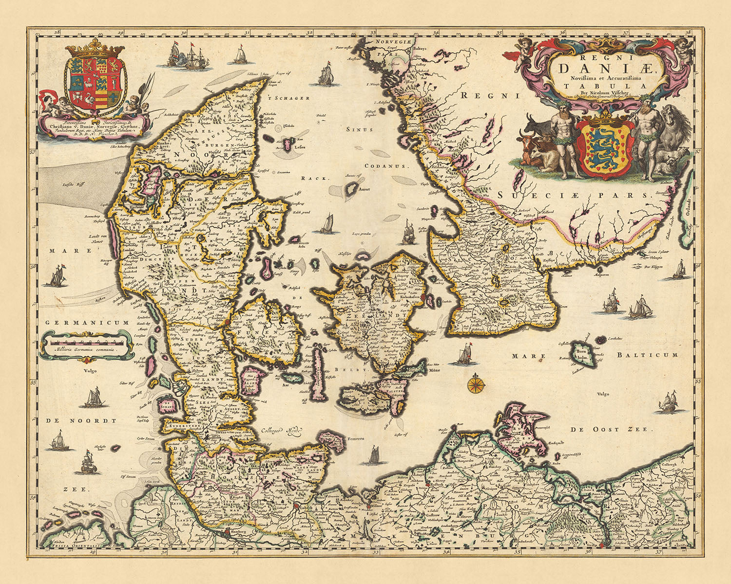
Fai un passo indietro nel tempo con questa mappa dettagliata della Danimarca, 'Regni Daniae: Novissima et accuratissima tabula', creata dal stimato Nicolaes Visscher II nel 1690. Tradotto in inglese, il titolo di questa mappa rivela la sua ampia copertura: 'Il Regno di Danimarca: La Mappa Più Nuova e Più Accurata'. Visscher, un rinomato cartografo dell'età d'oro olandese, presenta una prospettiva storica affascinante sulla regione, fornendo un'istantanea della Danimarca e dei suoi dintorni durante un periodo di grande cambiamento ed esplorazione.
La mappa presenta in modo prominente la città di Göteborg, situata sulla costa occidentale della Svezia. Conosciuta per i suoi canali in stile olandese e i viali alberati, Göteborg era una città marittima significativa al tempo della creazione di questa mappa. La capitale danese, Copenaghen, è mostrata anche in dettaglio, offrendo uno sguardo storico su una delle città più antiche d'Europa.
Più a sud, la mappa mette in mostra la città di Amburgo, un membro chiave della Lega Anseatica medievale e una grande città portuale nel nord della Germania. Attraverso lo stretto di Øresund, Malmö è anch'essa evidenziata, una città che ha storicamente servito come un collegamento cruciale tra la Scandinavia e il resto d'Europa.
Infine, la mappa illustra il Parco Nazionale del Mare di Wadden, un sito patrimonio dell'umanità UNESCO noto per il suo unico sistema di pianure tidali. Questa inclusione parla della natura completa della mappa, catturando non solo insediamenti urbani ma anche importanti punti di riferimento naturali. Questa mappa 'Regni Daniae: Novissima et accuratissima tabula' è una testimonianza delle abilità cartografiche di Visscher e un artefatto notevole della geografia storica.
Alcuni dei luoghi significativi mostrati su questa mappa:
Danimarca
- Copenaghen: La capitale della Danimarca, conosciuta come 'København' in danese. Era un importante centro commerciale durante l'età d'oro danese.
- Aarhus: Conosciuta storicamente come 'Århus', è una delle città più antiche della Danimarca ed era un importante centro culturale ed economico.
- Odense: Luogo di nascita di Hans Christian Andersen, era una città vivace con una ricca storia che risale all'età vichinga.
- Aalborg: Conosciuta per la sua architettura rinascimentale e il suo significato storico come porto durante il Medioevo.
- Esbjerg: Sebbene sia stata ufficialmente fondata nel 1868, ci sono stati insediamenti nell'area risalenti al XVI secolo.
Svezia
- Göteborg: Conosciuta come 'Göteborg', era un importante porto marittimo e fu fortemente influenzata dagli olandesi, dai tedeschi e dagli scozzesi che si stabilirono lì.
- Malmö: Una città significativa nella provincia di Scania, era un importante collegamento tra la Scandinavia e il resto d'Europa.
- Helsingborg: Una città con una posizione strategica nel punto più stretto dello stretto di Øresund, era storicamente conosciuta come 'Hälsingborg'.
- Lund: Conosciuta per l'Università di Lund, una delle università più antiche del Nord Europa, e la sua impressionante architettura romanica e gotica.
- Uppsala: Sede dell'Università di Uppsala, la più antica università della Scandinavia, e della Cattedrale di Uppsala, la cattedrale più grande della Scandinavia.
Germania
- Amburgo: Un membro chiave della Lega Anseatica medievale e una grande città portuale nel nord della Germania.
- Lübeck: Conosciuta come la 'Regina della Lega Anseatica', era un importante centro commerciale nel Medioevo.
- Rostock: Un centro significativo per le industrie marittime, è stato uno dei primi membri della Lega Anseatica.
- Kiel: Conosciuta per la sua università e la sua importante industria di costruzione navale.
- Flensburg: La città più a nord della Germania, è stata un importante punto commerciale e membro della Lega Anseatica.
Luoghi Naturali Notabili
- Parco Nazionale del Mare di Wadden: Un sito patrimonio dell'umanità UNESCO noto per il suo unico sistema di pianure intertidali.
- La Penisola di Jutland: La parte continentale della Danimarca, nota per le sue brughiere e dune di sabbia.
- Il stretto di Øresund: Una via d'acqua significativa che collega il Mare del Nord e il Mar Baltico.
- Il Mare del Nord: Un grande corpo d'acqua che ha svolto un ruolo cruciale nel commercio e nell'esplorazione durante l'era della vela.
- Il Mar Baltico: Una importante rotta marittima per il commercio, l'esplorazione e lo scambio culturale durante il Medioevo.
Eventi Storici Notabili (1600-1690)
- La Guerra di Kalmar (1611-1613): Un conflitto tra Danimarca-Norvegia e Svezia per il controllo dello stretto di Øresund e di altri territori.
- La Guerra dei Trent'Anni (1618-1648): Un conflitto importante che coinvolgeva varie potenze europee, con battaglie ed eventi significativi che si svolgevano nella regione.
- La Guerra di Scania (1675-1679): Un conflitto tra Svezia e Danimarca-Norvegia per il controllo della Scania e di altri territori.
Si prega di controllare attentamente le immagini per assicurarsi che una specifica città o luogo sia mostrato su questa mappa. Puoi anche contattarci e chiedere di controllare la mappa per te.
Questa mappa appare fantastica in tutte le dimensioni: 12x16in (30.5x41cm), 16x20in (40.5x51cm), 18x24in (45.5x61cm), 24x30in (61x76cm), 32x40in (81.5x102cm), 40x50in (102x127cm), 48x60in (122x153cm) e 56x70in (142x178cm), ma appare ancora meglio quando stampata in grande.
Posso creare stampe belle e grandi di questa mappa fino a 90in (229cm). Si prega di contattarmi se stai cercando opzioni di incorniciatura più grandi, personalizzate o diverse.
Il modello nelle immagini dell'elenco sta tenendo la versione 16x20in (40.5x51cm) di questa mappa.
La quinta immagine dell'elenco mostra un esempio del mio servizio di personalizzazione della mappa.
Se stai cercando qualcosa di leggermente diverso, dai un'occhiata alla mia collezione delle migliori vecchie mappe d'Europa e delle città europee per vedere se qualcosa attira la tua attenzione.
Si prega di contattarmi per verificare se una certa posizione, punto di riferimento o caratteristica è mostrata su questa mappa.
Questa sarebbe una meravigliosa idea regalo per un compleanno, Natale, festa del papà, partenza dal lavoro, anniversario o inaugurazione della casa per qualcuno delle aree coperte da questa mappa.
Questa mappa è disponibile come stampa giclée su carta opaca archivistica senza acidi, oppure puoi acquistarla incorniciata. La cornice è una bella, semplice cornice nera che si adatta alla maggior parte degli stili. Si prega di contattarmi se si desidera un colore o un materiale della cornice diverso. Le mie cornici sono dotate di un vetro acrilico super chiaro di grado museale (perspex/acrylite), che è significativamente meno riflettente del vetro, più sicuro e arriverà sempre in perfette condizioni.
This map is also available as a float framed canvas, sometimes known as a shadow gap framed canvas or canvas floater. The map is printed on artist's cotton canvas and then stretched over a handmade box frame. We then "float" the canvas inside a wooden frame, which is available in a range of colours (black, dark brown, oak, antique gold and white). This is a wonderful way to present a map without glazing in front. See some examples of float framed canvas maps and explore the differences between my different finishes.
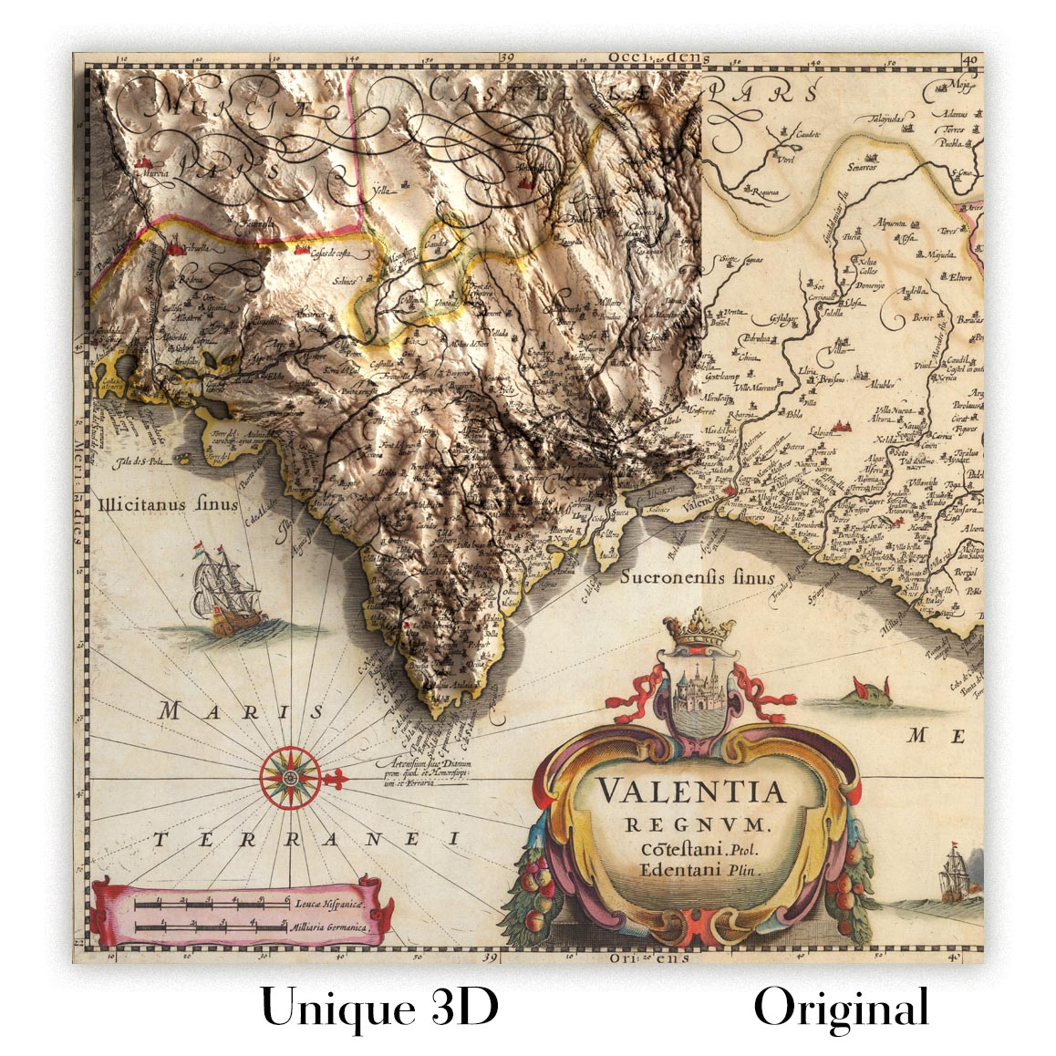
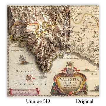
For something truly unique, this map is also available in "Unique 3D", our trademarked process that dramatically transforms the map so that it has a wonderful sense of depth. We combine the original map with detailed topography and elevation data, so that mountains and the terrain really "pop". For more info and examples of 3D maps, check my Unique 3D page.
For most orders, delivery time is about 3 working days. Personalised and customised products take longer, as I have to do the personalisation and send it to you for approval, which usually takes 1 or 2 days.
Please note that very large framed orders usually take longer to make and deliver.
If you need your order to arrive by a certain date, please contact me before you order so that we can find the best way of making sure you get your order in time.
I print and frame maps and artwork in 23 countries around the world. This means your order will be made locally, which cuts down on delivery time and ensures that it won't be damaged during delivery. You'll never pay customs or import duty, and we'll put less CO2 into the air.
All of my maps and art prints are well packaged and sent in a rugged tube if unframed, or surrounded by foam if framed.
I try to send out all orders within 1 or 2 days of receiving your order, though some products (like face masks, mugs and tote bags) can take longer to make.
If you select Express Delivery at checkout your order we will prioritise your order and send it out by 1-day courier (Fedex, DHL, UPS, Parcelforce).
Next Day delivery is also available in some countries (US, UK, Singapore, UAE) but please try to order early in the day so that we can get it sent out on time.
My standard frame is a gallery style black ash hardwood frame. It is simple and quite modern looking. My standard frame is around 20mm (0.8in) wide.
I use super-clear acrylic (perspex/acrylite) for the frame glass. It's lighter and safer than glass - and it looks better, as the reflectivity is lower.
Six standard frame colours are available for free (black, dark brown, dark grey, oak, white and antique gold). Custom framing and mounting/matting is available if you're looking for something else.
Most maps, art and illustrations are also available as a framed canvas. We use matte (not shiny) cotton canvas, stretch it over a sustainably sourced box wood frame, and then 'float' the piece within a wood frame. The end result is quite beautiful, and there's no glazing to get in the way.
All frames are provided "ready to hang", with either a string or brackets on the back. Very large frames will have heavy duty hanging plates and/or a mounting baton. If you have any questions, please get in touch.
See some examples of my framed maps and framed canvas maps.
Alternatively, I can also supply old maps and artwork on canvas, foam board, cotton rag and other materials.
If you want to frame your map or artwork yourself, please read my size guide first.
Alcune delle mie vecchie mappe sono ora disponibili come tele incorniciate. Per favore contattami se desideri ordinare una dimensione che non è disponibile nel mio negozio.
Le vecchie mappe su tela sono un'alternativa interessante alle mappe incorniciate in modo convenzionale. A seconda del tuo gusto personale e dell'arredamento della stanza, le mappe su tela possono "risaltare" un po' di più rispetto a una mappa incorniciata.
My maps are extremely high quality reproductions of original maps.
I source original, rare maps from libraries, auction houses and private collections around the world, restore them at my London workshop, and then use specialist giclée inks and printers to create beautiful maps that look even better than the original.
My maps are printed on acid-free archival matte (not glossy) paper that feels very high quality and almost like card. In technical terms the paper weight/thickness is 10mil/200gsm. It's perfect for framing.
I print with Epson ultrachrome giclée UV fade resistant pigment inks - some of the best inks you can find.
I can also make maps on canvas, cotton rag and other exotic materials.
Learn more about The Unique Maps Co.
Map personalisation
If you're looking for the perfect anniversary or housewarming gift, I can personalise your map to make it truly unique. For example, I can add a short message, or highlight an important location, or add your family's coat of arms.
The options are almost infinite. Please see my map personalisation page for some wonderful examples of what's possible.
To order a personalised map, select "personalise your map" before adding it to your basket.
Get in touch if you're looking for more complex customisations and personalisations.
Map ageing
I have been asked hundreds of times over the years by customers if they could buy a map that looks even older.
Well, now you can, by selecting Aged before you add a map to your basket.
All the product photos you see on this page show the map in its Original form. This is what the map looks like today.
If you select Aged, I will age your map by hand, using a special and unique process developed through years of studying old maps, talking to researchers to understand the chemistry of aging paper, and of course... lots of practice!
If you're unsure, stick to the Original colour of the map. If you want something a bit darker and older looking, go for Aged.
Se non sei soddisfatto del tuo ordine per qualsiasi motivo, contattami per un rimborso senza problemi. Si prega di consultare la nostra politica di reso e rimborso per ulteriori informazioni.
Sono molto sicuro che ti piacerà la tua mappa restaurata o la stampa d'arte. Lo faccio dal 1984. Sono un venditore Etsy a 5 stelle. Ho venduto decine di migliaia di mappe e stampe d'arte e ho oltre 5.000 recensioni reali a 5 stelle.
Utilizzo un processo unico per restaurare mappe e opere d'arte che richiede molto tempo e lavoro. Trovare le mappe e le illustrazioni originali può richiedere mesi. Utilizzo tecnologia all'avanguardia e incredibilmente costosa per scannerizzare e restaurarle. Di conseguenza, garantisco che le mie mappe e stampe d'arte siano superiori alle altre - ecco perché posso offrire un rimborso senza problemi.
Quasi tutte le mie mappe e stampe d'arte sembrano fantastiche a grandi dimensioni (200 cm, 6,5 piedi+) e posso anche incorniciarle e consegnarle a te, tramite un corriere speciale per oggetti di grandi dimensioni. Contattami per discutere delle tue esigenze specifiche.
Or try searching for something!


