


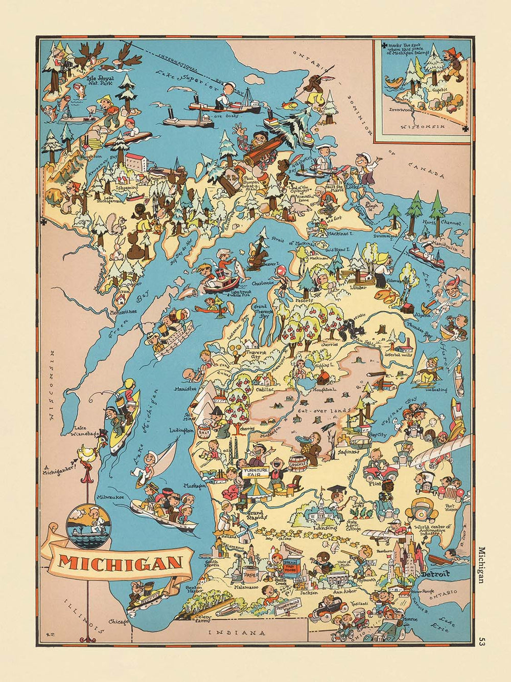


Mappa pittorica del Michigan di Ruth Taylor White, 1935: Detroit, Grandi Laghi, Legname, Auto, Frutteti, Ricreazione

-
![]() Handmade in Australia
Handmade in Australia
-
FREE Christmas delivery (check deadlines)
Free Christmas delivery in 3-4 days
Your map should be delivered in 3-4 working days with free delivery, worldwide.
The deadline for free Christmas delivery has almost passed. Please order as soon as possible and consider using Express Delivery.
We make maps by hand locally in 23 countries, including Australia
![]() . If you're buying a gift for someone in another country, we will make the map locally to them.
. If you're buying a gift for someone in another country, we will make the map locally to them.You will never pay import tax or customs duty.
Check the Christmas delivery guide for order deadlines. Delivery times are starting to slow down, and will continue to slow down towards Christmas.
Express delivery is available at checkout which can reduce the delivery time to 1-2 days.
Please note that personalised maps, and larger framed maps, can take longer to produce and deliver.
If you need your order to arrive by a certain date, contact me and we can discuss your options.
-
90 day money back guarantee
ⓘ
90 giorni per restituire e ricevere un rimborso
I prodotti possono essere restituiti entro 90 giorni per un rimborso completo, o cambio con un altro prodotto.
Per articoli personalizzati e su misura, potremmo offrirti un credito in negozio o una carta regalo non scadente, poiché non possiamo rivendere ordini personalizzati.
Se hai domande, contattaci. Per ulteriori informazioni, consulta la nostra politica di restituzione e cambio.

My maps are rare, museum-grade, restored old maps sourced from libraries, auction houses and private collections across the globe.
Framing & free personalisation available
1. Select your size
2. Frame & personalise your map
There is limited framing & personalisation capacity available. Order by 10am tomorrow for Christmas delivery.


Gift message & custom finish

If you want to add a gift message, or a finish (jigsaw, aluminium board, etc.) that is not available here, please request it in the "order note" when you check out.
Every order is custom made, so if you need the size adjusted slightly, or printed on an unusual material, just let us know. We've done thousands of custom orders over the years, so there's (almost) nothing we can't manage.
You can also contact us before you order, if you prefer!

- Handmade locally. No import duty or tax
- FREE Delivery by Christmas
- Love it or your money back (90 days)
- Questions? WhatsApp me any time
Own a piece of history
5,000+ 5 star reviews


Entra nel vibrante mondo dell'America degli anni '30 con "Michigan", una mappa pittorica affascinante originariamente realizzata da Ruth Taylor White nel 1935. Questa mappa, disegnata all'apice della Grande Depressione, è una celebrazione visiva dello spirito del Michigan, resa in uno stile giocoso e colorato che intrattiene e informa. Il suo titolo originale, semplicemente "Michigan", riflette l'attenzione dell'artista nel catturare il carattere unico e la cultura dello stato così come era quasi un secolo fa. Con ogni pennellata, White invita gli spettatori a vivere la ricchezza dei paesaggi del Michigan e la vita vivace delle sue comunità, rendendo questa mappa un delizioso artefatto storico per collezionisti e appassionati.
Ruth Taylor White era rinomata per il suo approccio immaginativo alla cartografia, trasformando le mappe tradizionali in opere d'arte vivaci. La sua collaborazione con l'editore Frank J. Taylor ha portato a una serie di atlanti pittorici che rimangono amati per il loro fascino e la loro intuizione storica. In questa mappa, l'arte di White brilla attraverso le sue illustrazioni giocose, che racchiudono i punti salienti economici, culturali e naturali del Michigan. Le scene vibranti non sono semplicemente decorative; offrono una finestra sul contesto sociale dell'epoca, rivelando come il Michigan venisse percepito e celebrato durante gli anni '30.
Il design della mappa è una lezione magistrale di cartografia tematica, che fonde umorismo con narrazione storica. I Grandi Laghi—Michigan, Superiore, Huron ed Erie—sono rappresentati con un tocco elegante, enfatizzando la geografia peninsulare unica dello stato. L'assenza del ponte di Mackinac, che non sarebbe stato costruito fino a decenni dopo, colloca sottilmente la mappa nel suo momento storico. Attraverso le Penisole Superiore e Inferiore, gli spettatori troveranno illustrazioni dettagliate delle industrie iconiche del Michigan: foreste dense alludono al fiorente commercio del legname, mentre scene di estrazione mineraria e disboscamento dominano il nord aspro. Vignette agricole, come frutteti e fattorie, evidenziano le terre fertili dello stato e le comunità laboriose.
La mappa di White è altrettanto attenta alle meraviglie ricreative e naturali del Michigan. Rappresentazioni giocose di pesca, navigazione e caccia evocano la reputazione dello stato come un rifugio per gli appassionati di attività all'aperto. La fauna selvatica, compresi pesci e cervi, è intrecciata nel paesaggio, sottolineando le ricche risorse naturali del Michigan. L'inclusione dell'industria automobilistica in espansione—un riferimento all'influenza globale di Detroit—ancora di più ancorano la mappa nel suo tempo, riflettendo il dinamismo economico che ha definito il Michigan all'inizio del ventesimo secolo. Queste scelte artistiche non solo informano ma anche deliziano, offrendo un'esplorazione stratificata di luogo e tempo.
Le città e i paesi della mappa sono etichettati con cura, offrendo uno sguardo affascinante sulla vita urbana e rurale del Michigan negli anni '30. Dalla potenza industriale di Detroit ai centri culturali di Grand Rapids, Flint e Ann Arbor, ogni insediamento è rappresentato con un senso di personalità e luogo. Anche comunità più piccole come Marquette, Escanaba e Sault Ste. Marie sono presenti, enfatizzando la diversità e l'interconnessione delle regioni del Michigan. Attraverso le sue illustrazioni vivaci e un design attento, "Michigan" di Ruth Taylor White resiste come un'opera d'arte e un documento storico, offrendo una prospettiva unica e coinvolgente sul passato dello stato.
Città e paesi su questa mappa
- Detroit
- Grand Rapids
- Flint
- Lansing
- Ann Arbor
- Dearborn
- Saginaw
- Kalamazoo
- Muskegon
- Bay City
- Jackson
- Battle Creek
- Marquette
- Escanaba
- Sault Ste. Marie
Caratteristiche e luoghi notevoli
- I Grandi Laghi (Lago Michigan, Lago Superiore, Lago Huron, Lago Erie) sono illustrati e etichettati in modo prominente.
- Lo Stretto di Mackinac è mostrato.
- Rappresentazioni pittoriche delle foreste e dell'industria del legname del Michigan.
- Illustrazioni di attività agricole, come frutteti e scene di agricoltura.
- Rappresentazioni di attività ricreative, come pesca e navigazione.
- Immagini di fauna selvatica, inclusi pesci e cervi, che evidenziano le risorse naturali del Michigan.
- Riferimenti visivi all'industria automobilistica, un motore economico chiave nel Michigan.
- La Penisola Superiore è illustrata con attività minerarie e di disboscamento.
- Lo stato è mostrato circondato dall'acqua, enfatizzando la geografia peninsulare del Michigan.
- La mappa include personaggi e scene giocose, in stile cartone animato, che aggiungono un tono fantasioso.
Contesto storico e di design
- Creato da Ruth Taylor White nel 1935.
- Editore: Frank J. Taylor (noto come editore/redattore per la serie di atlanti).
- Stile pictoriale/cartoon giocoso, vibrante e colorato, caratteristico del lavoro di Ruth Taylor White negli anni '30.
- Progettato per intrattenere e coinvolgere gli spettatori con illustrazioni vivaci e rappresentazioni umoristiche della vita locale.
- Offre un'istantanea dell'identità e della cultura del Michigan durante l'era della Grande Depressione.
- Riflette lo spirito creativo e umoristico della cartografia pictoriale dei primi del '900, mescolando arte e commento sociale.
- Fornisce un'idea delle percezioni e dei valori degli anni '30, così come l'evoluzione della creazione di mappe come mezzo informativo e di intrattenimento.
Si prega di controllare attentamente le immagini per assicurarsi che una specifica città o luogo sia mostrato su questa mappa. Puoi anche contattarci e chiedere di controllare la mappa per te.
Questa mappa appare fantastica in ogni dimensione, ma consiglio sempre di optare per una dimensione più grande se hai spazio. In questo modo puoi facilmente distinguere tutti i dettagli.
Questa mappa appare straordinaria in dimensioni fino a 50in (125cm). Se stai cercando una mappa più grande, per favore contattaci.
Il modello nelle immagini dell'annuncio sta tenendo la versione 18x24in (45x60cm) di questa mappa.
La quinta immagine dell'annuncio mostra un esempio del mio servizio di personalizzazione delle mappe.
Se stai cercando qualcosa di leggermente diverso, dai un'occhiata alla mia collezione delle migliori mappe antiche per vedere se qualcosa attira la tua attenzione.
Per favore contattami per controllare se un certo luogo, monumento o caratteristica è mostrato su questa mappa.
Questa sarebbe un'ottima idea regalo per un compleanno, Natale, Festa del Papà, partenza dal lavoro, anniversario o regalo per la casa per qualcuno delle aree coperte da questa mappa.
Questa mappa è disponibile come stampa giclée su carta opaca archiviata senza acidi, oppure puoi acquistarla incorniciata. La cornice è una semplice cornice nera che si adatta alla maggior parte degli stili. Per favore contattami se desideri un colore o materiale di cornice diverso. Le mie cornici sono dotate di acrilico super chiaro di grado museale (perspex/acrylite), che è significativamente meno riflettente del vetro, più sicuro e arriverà sempre in perfette condizioni.
This map is also available as a float framed canvas, sometimes known as a shadow gap framed canvas or canvas floater. The map is printed on artist's cotton canvas and then stretched over a handmade box frame. We then "float" the canvas inside a wooden frame, which is available in a range of colours (black, dark brown, oak, antique gold and white). This is a wonderful way to present a map without glazing in front. See some examples of float framed canvas maps and explore the differences between my different finishes.
For something truly unique, this map is also available in "Unique 3D", our trademarked process that dramatically transforms the map so that it has a wonderful sense of depth. We combine the original map with detailed topography and elevation data, so that mountains and the terrain really "pop". For more info and examples of 3D maps, check my Unique 3D page.
For most orders, delivery time is about 3 working days. Personalised and customised products take longer, as I have to do the personalisation and send it to you for approval, which usually takes 1 or 2 days.
Please note that very large framed orders usually take longer to make and deliver.
If you need your order to arrive by a certain date, please contact me before you order so that we can find the best way of making sure you get your order in time.
I print and frame maps and artwork in 23 countries around the world. This means your order will be made locally, which cuts down on delivery time and ensures that it won't be damaged during delivery. You'll never pay customs or import duty, and we'll put less CO2 into the air.
All of my maps and art prints are well packaged and sent in a rugged tube if unframed, or surrounded by foam if framed.
I try to send out all orders within 1 or 2 days of receiving your order, though some products (like face masks, mugs and tote bags) can take longer to make.
If you select Express Delivery at checkout your order we will prioritise your order and send it out by 1-day courier (Fedex, DHL, UPS, Parcelforce).
Next Day delivery is also available in some countries (US, UK, Singapore, UAE) but please try to order early in the day so that we can get it sent out on time.
My standard frame is a gallery style black ash hardwood frame. It is simple and quite modern looking. My standard frame is around 20mm (0.8in) wide.
I use super-clear acrylic (perspex/acrylite) for the frame glass. It's lighter and safer than glass - and it looks better, as the reflectivity is lower.
Six standard frame colours are available for free (black, dark brown, dark grey, oak, white and antique gold). Custom framing and mounting/matting is available if you're looking for something else.
Most maps, art and illustrations are also available as a framed canvas. We use matte (not shiny) cotton canvas, stretch it over a sustainably sourced box wood frame, and then 'float' the piece within a wood frame. The end result is quite beautiful, and there's no glazing to get in the way.
All frames are provided "ready to hang", with either a string or brackets on the back. Very large frames will have heavy duty hanging plates and/or a mounting baton. If you have any questions, please get in touch.
See some examples of my framed maps and framed canvas maps.
Alternatively, I can also supply old maps and artwork on canvas, foam board, cotton rag and other materials.
If you want to frame your map or artwork yourself, please read my size guide first.
Alcune delle mie vecchie mappe sono ora disponibili come tele incorniciate. Per favore contattami se desideri ordinare una dimensione che non è disponibile nel mio negozio.
Le vecchie mappe su tela sono un'alternativa interessante alle mappe incorniciate in modo convenzionale. A seconda del tuo gusto personale e dell'arredamento della stanza, le mappe su tela possono "risaltare" un po' di più rispetto a una mappa incorniciata.
My maps are extremely high quality reproductions of original maps.
I source original, rare maps from libraries, auction houses and private collections around the world, restore them at my London workshop, and then use specialist giclée inks and printers to create beautiful maps that look even better than the original.
My maps are printed on acid-free archival matte (not glossy) paper that feels very high quality and almost like card. In technical terms the paper weight/thickness is 10mil/200gsm. It's perfect for framing.
I print with Epson ultrachrome giclée UV fade resistant pigment inks - some of the best inks you can find.
I can also make maps on canvas, cotton rag and other exotic materials.
Learn more about The Unique Maps Co.
Map personalisation
If you're looking for the perfect anniversary or housewarming gift, I can personalise your map to make it truly unique. For example, I can add a short message, or highlight an important location, or add your family's coat of arms.
The options are almost infinite. Please see my map personalisation page for some wonderful examples of what's possible.
To order a personalised map, select "personalise your map" before adding it to your basket.
Get in touch if you're looking for more complex customisations and personalisations.
Map ageing
I have been asked hundreds of times over the years by customers if they could buy a map that looks even older.
Well, now you can, by selecting Aged before you add a map to your basket.
All the product photos you see on this page show the map in its Original form. This is what the map looks like today.
If you select Aged, I will age your map by hand, using a special and unique process developed through years of studying old maps, talking to researchers to understand the chemistry of aging paper, and of course... lots of practice!
If you're unsure, stick to the Original colour of the map. If you want something a bit darker and older looking, go for Aged.
Se non sei soddisfatto del tuo ordine per qualsiasi motivo, contattami per un rimborso senza problemi. Si prega di consultare la nostra politica di reso e rimborso per ulteriori informazioni.
Sono molto sicuro che ti piacerà la tua mappa restaurata o la stampa d'arte. Lo faccio dal 1984. Sono un venditore Etsy a 5 stelle. Ho venduto decine di migliaia di mappe e stampe d'arte e ho oltre 5.000 recensioni reali a 5 stelle.
Utilizzo un processo unico per restaurare mappe e opere d'arte che richiede molto tempo e lavoro. Trovare le mappe e le illustrazioni originali può richiedere mesi. Utilizzo tecnologia all'avanguardia e incredibilmente costosa per scannerizzare e restaurarle. Di conseguenza, garantisco che le mie mappe e stampe d'arte siano superiori alle altre - ecco perché posso offrire un rimborso senza problemi.
Quasi tutte le mie mappe e stampe d'arte sembrano fantastiche a grandi dimensioni (200 cm, 6,5 piedi+) e posso anche incorniciarle e consegnarle a te, tramite un corriere speciale per oggetti di grandi dimensioni. Contattami per discutere delle tue esigenze specifiche.
Or try searching for something!


